Page 1 of 1
RightCheer...
Posted: Tue Sep 18, 2012 2:05 am
by kantuckyII
A couple weeks ago, I got a 5.5 lbs bass about an hour or so after dark in about what I thought was 12' of water. I caught a 4 lb bass from the same location early this summer. I wondered what was down there holding them. The first one was a passing thought, the second was more of than just a passing thought. Well, after having Malones Marina in Ironton install my depth finder for me last week with Side Imaging, I now know...for this evening, I scanned that area and here's what I saw - the arrow marks where I hooked both those fish but it's around 14' of water
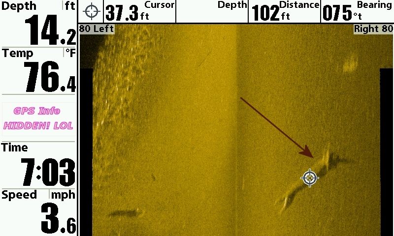
I have it here set so the water column is not being displayed
Re: RightCheer...
Posted: Tue Sep 18, 2012 2:41 am
by kantuckyII
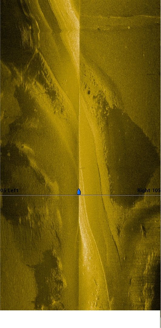
Here's 3 images stiched together that show an old roadbed. I knew there was one in the area but never dreamed it twisted this way but it's clear to see what it is
Re: RightCheer...
Posted: Tue Sep 18, 2012 9:15 am
by OZZIEOHIO
Wow thats a good one you got there, A poor boy like me could never afford one of those.
Re: RightCheer...
Posted: Tue Sep 18, 2012 9:51 am
by kantuckyII
You should ask Biggdowgg for a raise!
Re: RightCheer...
Posted: Tue Sep 18, 2012 10:05 am
by kantuckyII
Besides, I've been around you enough to know, it would just sit there and gather cob webs cause you'd never read the EXHAUSTIVE manual on it lol and you only fish one bait too so?
Re: RightCheer...
Posted: Tue Sep 18, 2012 4:59 pm
by wink
kantuckyII wrote:A couple weeks ago, I got a 5.5 lbs bass about an hour or so after dark in about what I thought was 12' of water. I caught a 4 lb bass from the same location early this summer. I wondered what was down there holding them. The first one was a passing thought, the second was more of than just a passing thought. Well, after having Malones Marina in Ironton install my depth finder for me last week with Side Imaging, I now know...for this evening, I scanned that area and here's what I saw - the arrow marks where I hooked both those fish but it's around 14' of water
I have it here set so the water column is not being displayed
Don't all the pro gurues say that fish will travel miles back to where they were caught? I don't see a 4 OR a 5.5 pound fish setting on that log...... in fact, I don't see a fish anywhere in all that water. I think you paid big bucks for a hoax.
Re: RightCheer...
Posted: Tue Sep 18, 2012 5:02 pm
by wink
kantuckyII wrote:Here's 3 images stiched together that show an old roadbed. I knew there was one in the area but never dreamed it twisted this way but it's clear to see what it is
The way it winds and twist arounf like you said, I think it is more likiely an old creek channel rather than a road bed.
Re: RightCheer...
Posted: Wed Sep 19, 2012 11:24 am
by kantuckyII
If you look to the left of the channel you can see the train changes sharply. It's obvious that the road went around the hill there
Re: RightCheer...
Posted: Wed Sep 19, 2012 11:25 am
by kantuckyII
That's very top of the image it kind a looks funny the reason for that yes I had start to turn the boat to the left to follow it and that shows up on the graph. It distorts the image if you're turning while recording
Re: RightCheer...
Posted: Wed Sep 19, 2012 11:39 am
by kantuckyII
wink wrote:kantuckyII wrote:A couple weeks ago, I got a 5.5 lbs bass about an hour or so after dark in about what I thought was 12' of water. I caught a 4 lb bass from the same location early this summer. I wondered what was down there holding them. The first one was a passing thought, the second was more of than just a passing thought. Well, after having Malones Marina in Ironton install my depth finder for me last week with Side Imaging, I now know...for this evening, I scanned that area and here's what I saw - the arrow marks where I hooked both those fish but it's around 14' of water
I have it here set so the water column is not being displayed
Don't all the pro gurues say that fish will travel miles back to where they were caught? I don't see a 4 OR a 5.5 pound fish setting on that log...... in fact, I don't see a fish anywhere in all that water. I think you paid big bucks for a hoax.
Well, perhaps LOL however if you stretch the picture out you can see some white streaks in it. Also, I had the graph set up to record 160 feet at the bottom, and that is spread over 8 inch diagonal screen. In other words, at those dimensions it might be likely that a fish would not show up on the screen.
However, it is hard to say where the fish were on that log there. As I mentioned, that log is sitting in 14 foot of water. The water temperature has cooled quite a bit. The fish might've moved into shallower water, or it might of went deeper, or, it could've gone to the store to buy some food or something. Perhaps, he took his lady friend and they went out to see a movie?
Or he could've been caught in the tournament the night before and had not made his way the 6 miles back to the ramp?
As far as the roadbed? I will map some more that area in the future, I do know there is a creek channel that comes underneath the roadway. I will show it to you in the future.
My opinion of the graph so far? If you're person not comfortable fishin deepwater or don't want to, I don't think you will enjoy it. I also don't think it's for the quick fix. I do know where that road lays now. I also know when they draw down the lake for the winter pool that road is only going to lay in 7 to 12 feet of water. If the Lord allows me, I guarantee you, ole' Kantucky will be tossing the jig and working that roadbed all the way across slower than molasses on a cold morning
Re: RightCheer...
Posted: Sat Sep 22, 2012 3:14 am
by kantuckyII
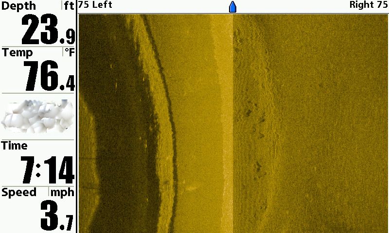
Wink, here's one for you. The way I see it, this is a roadbed that parallels a creek bed. The road is on the right, the creek on the left. Why do I see it that way? Ascending terrain appears lighter while descending terrain appears darker. This is another I took - in the same area as the others
Re: RightCheer...
Posted: Wed Sep 26, 2012 11:02 pm
by kantuckyII
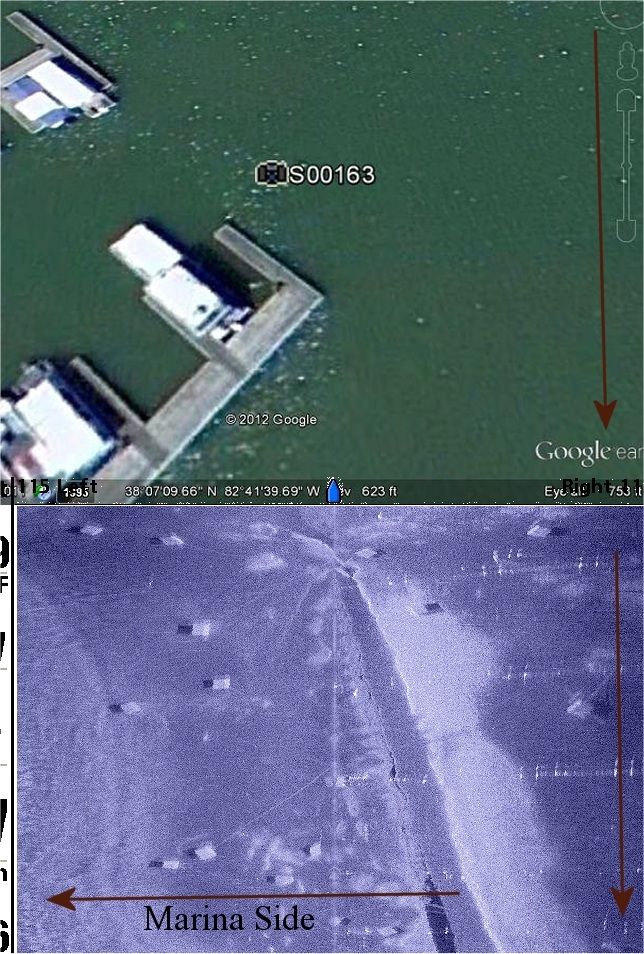
A cool image - it's the marina docks at Yatesville. The arrows on the right show the actual direction of travel. The top of the image is from Goggle Earth which shows the exact position the photo was snapped. The bottom shows what appears to be weighdowns and cables that hold down the docks
Re: RightCheer...
Posted: Wed Sep 26, 2012 11:29 pm
by OZZIEOHIO
Ill bet you go out and play with that fish finder all night or day and forget to do any fishing.
Re: RightCheer...
Posted: Thu Sep 27, 2012 3:06 am
by kantuckyII
I messed up. The marina side was on the right afterall
Re: RightCheer...
Posted: Mon Jan 13, 2014 7:20 pm
by OZZIEOHIO
That's cool